Warton Mires - working in partnership to deliver a healthy environment
for nature and the local community

What is the Warton Mires project?
The Warton Mires partnership project is a nature-based solution to improve the resilience and health of a local community and reverse the fortunes of threatened habitats and species in a protected landscape. It involves the construction of flood alleviation infrastructure, creation of wetland habitat and a footpath upgrade. The project will:
- Deliver flood alleviation for a community severely impacted by climate change
- Support local people with collaborative solutions through a partnership approach
- Create wetland habitat; considered to be the most biologically-diverse of all ecosystems and a natural solution to climate change
- Provide high quality green infrastructure to benefit the physical and mental wellbeing of local people
Project Update July 2022
The RSPB project team is currently focused on preparing the documentation to support a planning permission application for the project. The last few months have primarily been spent working on the flood risk modelling which is highly complex for this site.
- An updated Flood Risk Assessment is being prepared by consultants, WaterCo. The hydrology data in EA’s River Keer model has been updated as EA requested and now imported into the Warton Mires flood risk model. Simulations are currently being run and the model tested. Over the next couple of months the outputs of the modelling will be reviewed in conjunction with EA and Lancashire CC before the FRA is written up in the autumn. This will help inform the number and capacity of pumps recommended to improve surface water flood risk to Gardner Road.
- Environmental Impact Assessment Scoping Opinion was received in May from Lancaster City Council. The Ecological Impact Assessment, Heritage Impact Assessment and Habitats Regulations Assessment shadow screening report are currently being prepared. Other specialist chapters for the Environmental Statement will be commissioned when funding is secured and the FRA has been finalised.
- Discussions are ongoing between the RSPB, EA, Lancashire County Council, Lancaster City Council and Warton Parish Council to agree on responsibility and long-term funding for the pumping scheme.
- The detailed design of the flood embankment has been completed pending any additions/amendments required following the outputs from the updated Flood Risk Assessment work.
- Budget proposal has been received from United Utilities for the water main diversion which currently crosses the proposed line of the flood embankment. Approval has been granted from United Utilities for the proposed design/construction method for the other service crossings that will be required.
Project Status
Due to the delays in trying to resolve issues related to the flood risk modelling, our planned target for submission of the planning application has had to shift significantly to early 2023. If we are successful in obtaining planning permission we would hope to be constructing the scheme in early 2024. Construction can only take place during the summer months when ground conditions are suitable for the machinery required.
Project Funding
To date the project development has been funded by Natural England, EA and the RSPB.
We are targeting a few different funding sources for the capital costs of the project including Natural England Countryside Stewardship, Environment Agency Flood Risk and Coastal Management Grant in Aid and National Highways Designated Funds.
Consultation
The RSPB team meet regularly with representatives of the Warton Flood Action Group.
The next wider community consultation event will take place shortly before the scheme is submitted to Lancaster City Council as part of a planning permission application. The format of this event will be in accordance with Covid19 restrictions in place at the time.
Official public consultation will be conducted throughout the period when the plans are being considered by the planning authority.
Further Information
Please contact Jane Birch, Senior Project Manager, RSPB: This email address is being protected from spambots. You need JavaScript enabled to view it.
Project Background – Warton Mires
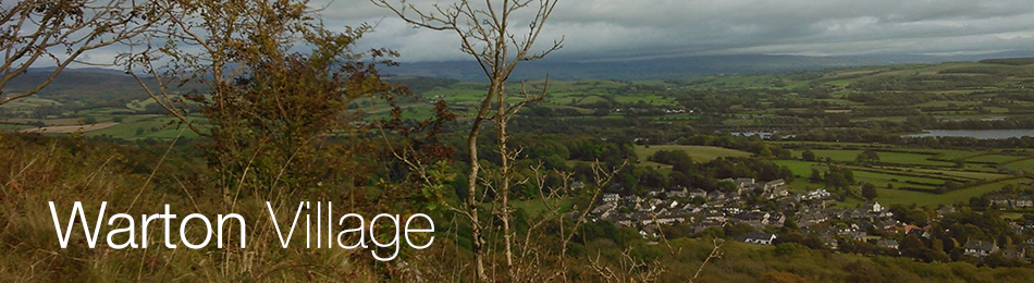
Warton Mires is a large area of land located adjacent to Warton village, extending from Warton Grange Farm in the west, to the railway line and Threagill Lane to the east, with the River Keer running along the southern edge. The RSPB and the Arnside and Silverdale AONB Landscape Trust purchased 34ha (an area equivalent to more than 40 football pitches) of Warton Mires in June 2018. The ambition to acquire the land was made possible by an opportunity presented by Lancashire County Council/Lancashire Local Enterprise Partnership, that arose from the need to create high quality habitat for breeding lapwings, to mitigate against the loss of this elsewhere in the county. This was coupled with additional funding from the AONB Landscape Trust, Banister Charitable Trust and the RSPB.
As locals know, the low-lying fields on Warton Mires which form part of the River Keer floodplain can stay quite wet into the early summer. Sections of the site already have the clear visual appearance of being a ‘wet grassland’ - the perfect habitat for breeding lapwings. Historically Warton Mires has supported a good population of breeding lapwings, but changes in farming practices, particularly intensification, have seen these numbers significantly diminish. The RSPB will bring a change to managing the land less intensively, with much lower numbers of livestock and by avoiding grazing during the breeding season. Cutting will take place where necessary to create the right height for the vegetation required by lapwings, and some surface water will be kept in spring. This will ensure the lapwings have their desired opportunities to feed and raise their chicks.
Whilst Warton Mires is the ideal site to provide habitat for breeding lapwings, it has an even greater appeal when the potential for other wildlife, but also for you – the local people, is taken into account too. Restoring the site for lapwings will provide the perfect home for a variety of other wading birds such as black-tailed godwits, redshanks and curlews, as well as ducks including wigeons, teal, pintails, shovelers and gadwalls. For local people, it creates an opportunity to alleviate flood risk, improve water quality and offers a nearby spot to enjoy nature.
Warton Mires floods extensively during many winters, with high tides often preventing the escape of water into the adjacent river Keer, causing it to back up towards the village. As locals are all too aware, this has resulted in flooding of residential properties along Gardner Road in Warton village on a number of occasions, most notably during Storm Desmond in December 2015. The frequency of flooding is only likely to get worse with climate change predictions. One of the solutions to reduce the risk of flooding for residents, is to construct a flood embankment around the northern boundary of the site. Previously this had not been financially viable based on the flood benefits alone but, when combined with the benefits to wildlife, the two are complementary and the scheme became more attractive to multiple funding sources. The RSPB has consulted extensively with residents and had overwhelming support for the proposed scheme. Flood alleviation for this community has only been made possible by developing a scheme to manage the site for wildlife. Delivering for wildlife is the key to unlocking the community flood alleviation benefits.
As locals, you will have free access to a nature reserve on your doorstep and it will provide increased opportunities to appreciate and engage with nature. It is well recognised that this delivers health and wellbeing benefits for people of all ages. The public right of way that runs through the site but that frequently sits underwater for parts of the year will be improved. The current design allows for raising and upgrading the footpath so that it would be accessible for a greater part of the year than it is now. This would provide better access links between Warton, Millhead and Carnforth.
A feasibility study was commissioned in December 2016, funded by Natural England Countryside Stewardship, to evaluate the potential to deliver this multi-functional scheme. This work is ongoing with further funding provided by the Environment Agency to prepare the technical design and supporting documents required to accompany a planning permission application. The project is being guided by a Partnership Group which the RSPB established in 2018 in which the following organisations are also represented; Natural England, Environment Agency, Lancaster City Council, Warton Parish Council, Gardner Road residents group, Arnside and Silverdale AONB, AONB Landscape Trust, Lune Rivers Trust, Lancashire County Council, Centre for Ecology and Hydrology and United Utilities.